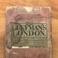
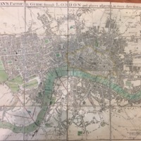
Luffman's faithful guide through London and places adjacent : in every direction from St. Paul's.
Dublin Core
Title
Luffman's faithful guide through London and places adjacent : in every direction from St. Paul's.
Subject
A 19th century cloth map detailing the entire city of London using St. Paul's cathedral as the starting point for travelers. This map also shows the transition to modern London by outlining upcoming changes in construction on the map.
Description
Map comes in a small, square, brown holder. The map folds in 9 ways, and is made of map paper glued to cloth. Parks and greenery are highlighted in green, bodies of water are highlighted in blue, and intended improvements are highlighted in red.
Creator
John Luffman
Source
call number: Rare Bk Uncat 2109, in Hargrett Special Collections Library
Publisher
I. Luffman
Date
1810
Format
physical object; printed map glued to cloth; hand highlighted, square storage container
Language
English
Type
Map/Printed Text
Identifier
call number: Rare Bk Uncat 2109
Coverage
The city of London and surrounding streets during a transition period in the 1800s.
Citation
John Luffman, “Luffman's faithful guide through London and places adjacent : in every direction from St. Paul's.,” Write@UGA: History and Horizons, accessed April 20, 2024, https://hyperglyphics.net/omeka/items/show/29.

